
Where arrowheads turn up
Found Ground Labs · October 2026
People camped where life was easier: near water, on dry ground, close to food and good stone. Thousands of years later, working the farm fields brings what they left up to the surface. If you know how they picked a spot, you know where to start walking.
This guide covers the places that turn up points again and again, and how to read them on a map before you go.
Start with water
Nearly every camp was near fresh water, but not just any water. A big river floods, and its bottomland was often wet. A small, steady feeder creek, the kind that runs into a larger stream, gave water without the worst of the floods.
When you look at a map, follow the small creeks first. A field that touches a feeder creek, or sits just above one, is worth a look. A field a mile from any water usually is not, unless there is a spring or an old wet spot nearby.
The first rise above the creek
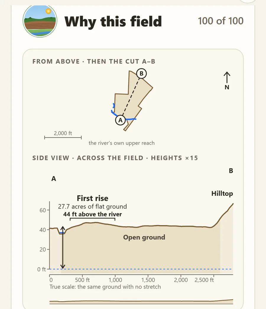
The best ground is often the first rise: the first flat shelf of land above a creek or river, high enough to stay dry in a flood. Geologists call it a terrace. It was dry, level and well drained, close to the water but out of its reach, with a view over the bottom.
On the ground it is easy to miss. A terrace may stand only a few feet above the flood plain, and years of farming soften its edge. Look for a gentle step up from the low ground, often with lighter, better-drained soil on top.
Walk the edge of the rise first, the strip nearest the creek. Then work back across the flat.
Where two creeks meet
Places where two streams join were busy. Valleys were the easy paths through the country, so a fork sat on a natural travel route. It had two sources of water and more kinds of plants and animals close by. A rise in the fork between two creeks is a classic spot.
Old creek channels
Creeks move. Over centuries they swing back and forth across the valley and leave old channels behind: low, curving strips that may now be dry, filled in or farmed right over. A camp that once sat on a creek bank may now be a long walk from any water.
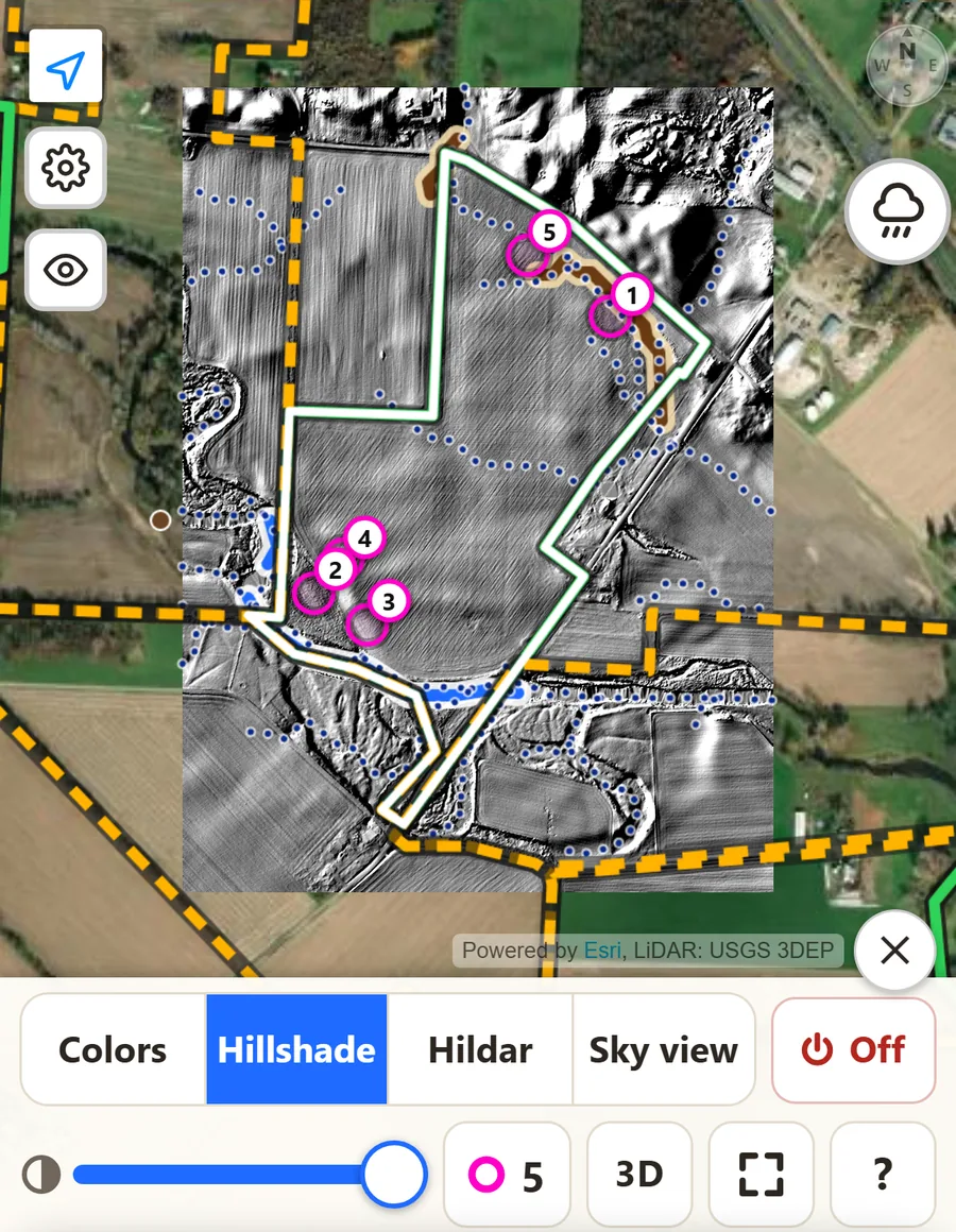
These old channels are hard to see standing in a field, but they show up well on a LiDAR map, which shows the bare shape of the ground. A small rise beside a deep old channel is a good place to begin.
Near good flint
Points were made from stone, and good stone was not everywhere. People traveled to the best flint, quarried it, and roughed out blanks and tools nearby. Fields near a known flint source often show lots of flakes and broken pieces, the leftovers of that work.
The best-known source in Ohio is Flint Ridge, now Flint Ridge State Memorial in Licking County, where people dug Vanport flint for thousands of years. You can visit and see the old quarry pits, but collecting there is not allowed. Good flint was carried and traded a long way, so a point made of it can turn up far from where the stone was dug.
Other good signs
- Springs and seeps. A spring near a rise is a strong draw.
- Dry knolls in wet ground. A small sandy or gravelly rise in low, wet country was a dry island, and it was used.
- Flakes and fire-cracked rock. Whole points are rare. The waste from making them is not. Flakes, reddened or cracked rock and darker patches of soil mean people spent time there. Slow down and walk that area closely.
How First Rise shows it
First Rise looks for these same things in crop fields along Ohio's creeks, and shows you why a field scored:
- Feeder creek: a small creek that runs through or along the field and feeds a river.
- First rise: whether the field holds flat, dry ground just above the creek, and how much.
- History: old sites nearby on public records such as the 1914 Mills atlas.
- Extras: terrace soil from the USDA soil map, an old creek bed, and a small bonus near a prehistoric flint quarry named in the old published reports.
Inside each field, LiDAR shows the bare ground, down to half a meter where the county's survey allows, and hot spots mark gentle rises beside deep old channels, numbered best first. The soil map colors the field by terrace, flood plain, upland and wet hollow.
A good score is a place to start, not a promise. Points can turn up anywhere, and a field with the right shape may hold nothing at all. The map tells you where to walk first. Your eyes do the rest.
Hunt the right way
- Always get the landowner's permission first.
- Surface hunt only. Never dig.
- Mounds and earthworks are graves and sacred places. Look, but don't touch.
- Collecting on public land is against the law in Ohio.
- If you find bones, stop. Leave them where they are and call the county sheriff or coroner right away. Ohio and Indiana both have laws that protect human remains and graves.
Rules differ from place to place and change over time. Check them before you go.